| First Page | Previous Page | Next Page |
Trengwainton House, a commodious and interesting mansion, is remarkable for its fine position, and for the extent of the surrounding woods. From Trengwainton Cairn, a very romantic spot, the scenery is highly picturesque; on its top is an ancient granite cross.
Lanyon, properly Lanion, from Lan-eithon, the furzy croft, was in former days the property and residence of the ancient family of the same name. The site of the old mansion is occupied by a substantial farm house. There was formerly a chapel at this place, of which there are little or no remains. The estate, which measures 471 acres, comprises some tolerable grazing and arable land skirted by large tracts of moorland, commons, and furze crofts, throughout which are scattered innumerable small unshapen boulders or blocks of granite.
On the coarse lands of this estate, by the side of the highway leading from Madron churchtown to Morvah, stands the celebrated cromlêh called Lanyon Quoit. It consists of a large granite table 171/3 feet in length, and at the greatest breadth 8¾ feet; its form is irregular, and its average thickness about 18 inches. This table or capstone is supported by three unhewn pillars also of granite, its elevation being about 5 feet. The capstone was thrown down during a thunderstorm in 1816, and replaced in 1824 with the same machinery by which Lieut. Goldsmith restored the Logan Rock to its position. This was also done through the instrumentality, and partly at the cost of Davies Gilbert, Esq.
Borlase describes this ancient monument as high enough for a man on horseback to pass under it. This cannot now be done, and there is a great probability that the supporters were sunk deeper in the ground, when it was replaced in 1824. A few yards to the south of the cromlêh, which stands nearly north and south, are the remains of a small barrow.
About half a mile to the west of Lanyon farm house, in the middle of a hilly field on the same estate, is another cromlêh, known as West Lanyon Quoit. It was discovered in 1720, within a mound of earth and stones, after nearly a hundred cartloads had been removed. The capstone or table, which had slipped off, measures about 18 of Lanyon farm house, in the middle of a hilly field on the same estate, is another cromlêh, known as West Lanyon Quoit. It was discovered in 1720, within a mound of earth and stones, after nearly a hundred cartloads had been removed. The capstone or table, which had slipped off, measures about 182/3 feet in length by 10½ in breadth. The south supporter, against which it leans, is 6 feet high and 5 wide. The west supporter was about the same height and nearly 9 feet wide; that on the east was 10½ feet wide, and with the other two formed almost a triangular kist-vaen. In digging under this cromlêh there was found a broken urn with ashes, half of a skull, the thigh bones and most of the other bones of a human body. These were lying in such a manner as proved that the grave had been opened before; and there is a tradition that the person who pulled down this cromlêh immediately fell under great misfortunes;—his cattle died and his crops failed, so as to leave a warning impression on the minds of his neighbours. Lanyon is the property of W. Rashleigh, Esq., of Menabilly.
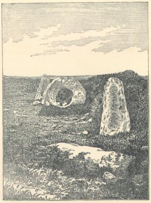
THE MEN-AN-TOL, MADRON.
On the boundry of this parish and Gulval and near the Lanyon estate is the Mên-an- tol, or holed stone; it stands between two others, at the distance of seven or eight feet from each. The holed stone is 3 feet 6 inches high by 4 feet 6 inches in breadth at the base; the hole which faces the other stones, is 26 inches in diameter on one side and 19 inches on the other. There is a tradition connected with it, that persons afflicted with the crick or rheumatism, were cured by passing through the hole; hence it is locally termed the “Crick-stone.”
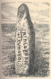
The Mên Scriffys, Scryffen or Scryfa, spoken of by Hals, is in the parish of Gulval about a mile to the north-east of Lanyon. It is a rough granite pillar, 9¾ feet long, 12/3 wide, and 1½ thick, and bears the inscription—
RIALoBRAN CUNoVAL–fIL–
which extended would be Rialobranus Cunovali filius; “Rialobran the son of Conoval.” A miner, who had heard that crocks of gold were occasionally found under stone Pillars, dug around the inscribed stone until he nearly lost his life by the fall of the huge mass. It was replaced in its original position about the year 1862.
The popular tradition is that a great battle was fought near this pillar; that one of the leaders was slain and buried here; that this stone marks his place of sepulture; and that its length was the exact height of the warrior.
About a quarter of a mile to the west of Penzance is Castle Horneck, the Iron-castle thought to be the site of a castle so denominated from its supposed strength, and built by the family of Tyes, who were lords of this district early in the times of the Plantagenets, and whose title as baron Tyes became extinct in 1322.
“Castle Hornocke,” writes Norden, “an auntient ruyned castle standinge on a mounte nere Pensans, and as it seemeth in former times of some accompte.”
The present handsome residence was built by the Rev. Walter Borlase, D.C.L., Vice-Warden of the Stannaries, and for more than 55 years vicar of this parish.
Dr. Borlase was universally respected as a man of ability and learning, and for firmness and decision of character. He was the eldest son of John Borlase, Esq., of Pendeen in S. Just, M.P. for S. Ives, and brother of Dr. William Borlase, rector of Ludgvan, the celebrated antiquary.
Dr. Walter Borlase married Margaret, daughter of the Rev. Henry Pendarves vicar of Paul; and he is said in consequence of this marriage to have quitted the profession of the law in which he had been educated. They had a numerous family of sons and daughters; but none of the sons having left a son, the family estate passed under an entail to the descendants of Dr. William Borlase, and the representatives of his great grandson, the late Samuel Borlase, Esq., are the present proprietors.
The arms of Borlase are,— Ermine, on a bend sable two hands and arms issuing from the clouds at the elbows, all proper, rending a horseshoe or.
On the top of a hill which rises behind the finely wooded grounds of this delightful residence, some remains of an ancient earthwork may still be seen, the area of which measures about an acre and half, and is now planted with firs. This encampment is known by the name of Lesingey Round, and is still in good preservation.
On the opposite side of the parish near the entrance to Penzance, is another larger round or entrenchment called Castle Lescudjack or Lesgudzhek, the “castle of the bloody field.” This earthwork, called by Hals Les-cad-dock Castle, has, through agricultural improvements, nearly disappeared.
Truen Round, immediately above the village of Truen, is about 125 feet in diameter, and encloses the top of the eminence on which it stands. Near its centre a circular Pavement of uncut broad granite slabs, about ten feet in diameter, was discovored in 1845 beneath the turf; and at a short distance from it, the stones of a hand-mill or quern. Each stone is thirteen inches in diameter, and four inches thick. A large stone muller, two feet in diameter and nine inches high, was also found near the millstones. These articles are Preserved in the Antiquarian museum at Penzance.
On the top of Mulfra Hill, the “round bald hill,” in the detatched part of the parish, stands the cromlêh called Mulfra Quoit. The capstone is 9¾ feet by 14¼, including a piece evidently broken off and lying near it, The kist-vaen is 62/3. feet long, and 4 wide; the south supporter is gone, and on that side the capstone has fallen, and rests on the others at an angle of about 45°. It is said to have been displaced during a thunder-storm in 1752. On the same hill, a little to the north of the cromlêh, are the remains of four or five barrows.
On a commanding hill on the northern border of the parish adjoining Morvah, stand the remains of one of the most perfect of the hill castles of Cornwall, Ch’ûn Castle, Ch’ûn or Chy-an-oon, signifies the “house on the downs.”
“The most regular and curious of this kind,” (hill castles) writes Borlase”, is Castle-Chûn. The entrance faces W.S.W. where having passed a ditch, you enter the outmost wall, five feet thick, which is called the iron gate way, and leave on the left hand the wall twelve feet thick for strengthening the entrance; on the right there is a wall which traverses the principal ditch, thirty feet wide, till it reaches within three feet of the principal wall, eight feet thick at the present top, but in the foundation thicker, then turns away parallel to it, leaving a narrow passage of three feet wide, as a communication betwixt the entrance and the ditch. The entrance, flanked on the right by a wall, and on the left by an opposite wall, admits by the passage through the great wall into several lodgments, which are formed by a circular line of stone work about three feet high, parallel to the wall, and several partitions spring as it were from the centre of the whole work, and reaching from the line to the principal wall: these divisions are all thirty feet wide, but of unequal bigness. The area within these works is 125 feet from east to west, and 110 from north to south. The principal foss has four traverses, which secure the entrance, and two more which divide the remaining part of the foss nearly into three equal parts. By the ruins of these walls, I judge that the outermost could not be less than ten feet high, and the innermost about fifteen, but rather more, and both well perfected; the apartments within were probably shelters from the weather. Some rude one of like use we have taken notice of; but these are much more regularly disposed, and indeed the whole of this work, the neatness and regularity of the walls, providing such security for their entrance, flanking and dividing their foss, shews a military knowledge superior to that of any other works of this kind which I have seen in Cornwall.”
Chûn Castle, which stands on the Bosullow estate, has been greatly mutilated, large quantities of the stone having been carried away and used in other buildings.
Its ground plan and general arrangement however can still be distinctly traced, and portions of the walls show good examples of this kind of ancient masonry. In one of the compartments on the north side is a well, which was originally walled around, having steps descending to the water.
On the sides of the hill and on the surrounding common are great numbers of small barrows, and heaps of stones about three feet in height. Some of the barrows have been opened, but no urns or bones were found; but the earth was discoloured as by fire. They are thickly scattered about, as if there had been a desperate battle on the spot, and the dead had been burnt and their ashes buried where they had fallen.
About a quarter of a mile to the eastward of Ch’ûn Castle are the remains of to the eastward of Ch’ûn Castle are the remains of Old Bosullow,—here may be traced the ruins of upwards of thirty enclosures of a rude circular form, varying from eight to forty feet in diameter. Some of the larger ones appear to have been originally divided and subdivided; the walls are composed of rough stones without mortar, and vary in elevation from five feet to mere foundations. There are neither windows nor chimneys, and the entrances are very narrow, averaging but 2¾ feet.
From the centre of one of these huts, earth and stones to the depth of a foot were removed, and beneath was found a thin layer of fatty black mould, in which was a small quantity of charred wood, a great number of burnt stones, and several fragments of pottery. One of the huts had a rude pavement of flat stones; many of them appear to have been built around a central area, with a strong and well preserved entrance. An ancient protected roadway leads from the buildings to the castle. Latterly, in making some excavations within the huts, a quern was found.
In a field adjoining the south side of the road, leading from Penzance to S. Just, near Newbridge, on the tenement of Trewen on [or?] Truen, is what may be termed a two-stone monument. It consists of two tall unhewn granite pillars, ten feet apart from each other, and in a line bearing E.N.E. In 1752 the ground between these stones was opened and a pit found which measured 6 feet 6 inches long 2 feet nine inches wide, and 4 feet deep; near the bottom was a large quantity of black greasy earth, but no bone could be seen. This grave came close to the westernmost and larger stone, next to which it is supposed the head of the buried person lay.
Nancealvern, which is situated within beautifully wooded grounds adjoining the borough of Penzance, was formerly the property of Mr. Carverth, who, after building a good house on it, died in very embarrassed circumstances, which gave rise to a great extent of litigation, This place was purchased by one of the Ustick family, and was carried by an heiress to the Scobells, in whose representatives it is still vested. This branch of the Scobell family, which claims to be of Cornish origin, removed hither from Nutcombe, in East Allington, Devon, about a century ago. The Rev. Dr. Scobell married the heiress of Ustick of Leah in S, Burian.
The arms of Scobell are,—Per pale argent and gules, three fleurs-de-lis, and a label in chief counterchanged. Crest,—A demi-lion rampant, holding a fleur-de-lis in his dexter paw.
Near Nancealverne is the Penzance Public Cemetery, constructed in 1854. It consists of about four acres of land, divided by a low wall, and tastefully laid out and planted with shrubs. On each side of the entrance is a substantial mortuary chapel, and over it a gable with a bell. The Cemetery, which is a well-kept and interesting place, is open to the public on Sunday afternoons.
The workhouse of the Penzance Union adjoins the churchtown; the Union comprises the parishes of S. Erth, Ludgvan, Lelant, Towednack, S. Ives, Zennor, Perranuthnoe, S. Hilary, Marazion, S. Michael’s Mount, Paul, Gulval, Penzance, Madron, Morvah, Sancreed, S. Just in Penwith, Burian, S. Levan, Sennen, and the Scilly Islands.
Pedigree of the Family of LANION of LANION, now Lanyon.
(From the Heralds’ Visitation of 1620).
[![]() Regrettably, I have had to insert this
tree as an image as I can find no other way to format it. As a
consequence it will not be viewable by a text or speech
browser. If you need help, please contact me. The surnames
included, other than Lanyon/Lanion are Ruthfrey, Trelissick,
Trugian, Rashleigh, Tresprisin, Angrom, Arundell, Treskillard,
Cosgarne, Penrose, Noy, Wood, Militon, Chappel, Trewren, Ley,
Kempthorne, Tonkin, Mooring, De la Moor]
Regrettably, I have had to insert this
tree as an image as I can find no other way to format it. As a
consequence it will not be viewable by a text or speech
browser. If you need help, please contact me. The surnames
included, other than Lanyon/Lanion are Ruthfrey, Trelissick,
Trugian, Rashleigh, Tresprisin, Angrom, Arundell, Treskillard,
Cosgarne, Penrose, Noy, Wood, Militon, Chappel, Trewren, Ley,
Kempthorne, Tonkin, Mooring, De la Moor]
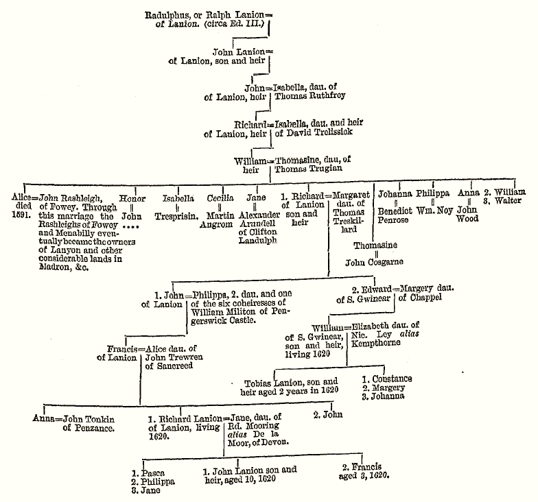
ARMS,—Gules, a castle with four towers argent, standing on the waves of the sea azure, in chief a falcon hovering with bells proper, quartering Militon.
CREST,—A falcon with bells, rising.
| First Page | Previous Page | Next Page |
©2001–03 (last updated 30 Mar 2003) Rick Parsons, Bristol, England