
I can help with all resources marked ![]() , copyright permitting.
, copyright permitting.
For a simple view of parishes, I refer you to my own online map (44K).
See also Bibliography, Gazetteers, Land Records and Aerial & Satellite Views.
I do not sell books! The small
prices at the end of some listings are there as a guide only.
In an effort to improve my library (at modest cost) I am
interested in obtaining copies of books marked ![]() . Please contact me with details if you have
these on offer.
. Please contact me with details if you have
these on offer.
I also have an online Ordnance
Survey map (200K). More information regarding this
and other current and historical maps can be obtained from the
![]() Ordnance Survey.
Ordnance Survey.
Published maps of Cornwall have existed since the mid C16th. Good summaries (but much more than included on this page) are provided by
![[YES]](images/Ballred.gif) Barker, Katherine and Kain,
Roger eds. Maps and history in South West England; University
of Exeter Press, Exeter: 1991. ISBN 0 85989 373 1.
Barker, Katherine and Kain,
Roger eds. Maps and history in South West England; University
of Exeter Press, Exeter: 1991. ISBN 0 85989 373 1.- Quixley. Antique maps of Cornwall and the Scilly Isles;
![[WANT]](images/Ballyell.gif) .
.
It would be impossible to produce a complete list, particularly of the various editions of the Ordnance Survey, but notable examples are, in date order
- Christopher Saxton c1574.
This is a county map created as part of an atlas of
England and Wales and effectively commissioned by Queen
Elizabeth I. Made with the threat of a Spanish invasion, this
was the first complete mapping of the country. A book which
contains the whole set in their bright original colours and
with an introduction by William Ravenhill is
“Christopher Saxton’s 16th Century Maps—The
counties of England and Wales” Chatsworth: 1992 ISBN 1
85310 354 3. There is a scan of another edition (rather
nicer I think) on the University of Pennsylvania’s
![[Off Site]](images/world.gif) Introduction to Renaissance
Studies page (second from last thumb-nail in
“Section 1: Introduction” 400K).
Introduction to Renaissance
Studies page (second from last thumb-nail in
“Section 1: Introduction” 400K). - John Norden c1597. This
edition consists of a county map and also maps of each
individual Hundred. The survey was based on that of Saxton
but considerable extra work was done by Norden to add detail.
An excellent collotype reproduced set of an original
manuscript copy with commentary by William Ravenhill was
published by Exeter University in 1972 (SBN 900771 35
6).£32. Speculi Britanniae Pars: A topographical and
historical description of Cornwall; William Pearson,
London:1728.£1600 These are the same
maps but engraved and with additional text added. 200 were
published but Reprints remained available until the
C19th despite better being available. This has
been reprinted in Newcastle upon Tyne: 1966.
£25 The late
Brian Jelbert had an online scan of the Penwith Hundred (110K) which has been
preserved by his brother Roger.
- John Speed 1610. This is a
county map from an atlas of the whole of Britain all based on
earlier works, mostly of Christopher Saxton. It is widely
available in facsimile published on “parchment”
by The Olde Map Company of Penzance. A book which contains
the whole set in contemporary colourwash and with a
commentary by Nigel Nicolson is “The counties of
Britain—A Tudor atlas by John Speed” Pavilion in
association with the British Library: 1988 ISBN
1-85145-131-5. I have also seen smaller volumes with a
subset of the maps e.g. just the West Country. Alan Stanier
has a complete scan on his Cornwall (Link Broken 17 Mar
2015) page (560K) or for a more
manageable extract of just West
Penwith.
- Johan Blaeu/Bleau 1648. I
don’t know a lot about this map or it’s Dutch
cartographer, but it is similar in content and style to the
John Speed and hence, indirectly, to the one of Christopher
Saxton. David Trounce has a scan in four parts
(c350K each) on his page from which I have extracted West Penwith.
- Richard Blome 1673–85. Jon Quixley informs me that there were three editions of this map. The first published in 1673 dedicated to John Granville, the second edition first version published in 1681 (very rare) dedicated to Hender Roberts, a second version again dedicated to John Granville and a third edition in 1685 dedicated to James Tilie. A scan of this third edition (490K) was on Alan Stanier's web site which has now vanished so I have uploaded it here.
- The Lanhydrock Atlas (probably by Joel Gascoyne)
1693–9. 258 large scale (1:4000) maps of Lord
Robartes property scattered all over Cornwall. Nine of these,
located in Penwith, are reproduced in the book “Three Hundred Years on Penwith
Farms” Penwith Local History Group: 1994 ISBN 0 9524744
0 9.
- Grenville Collins 1693. Land’s End and the Isles of Scilly chart 18" x 22".
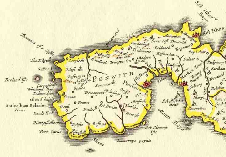
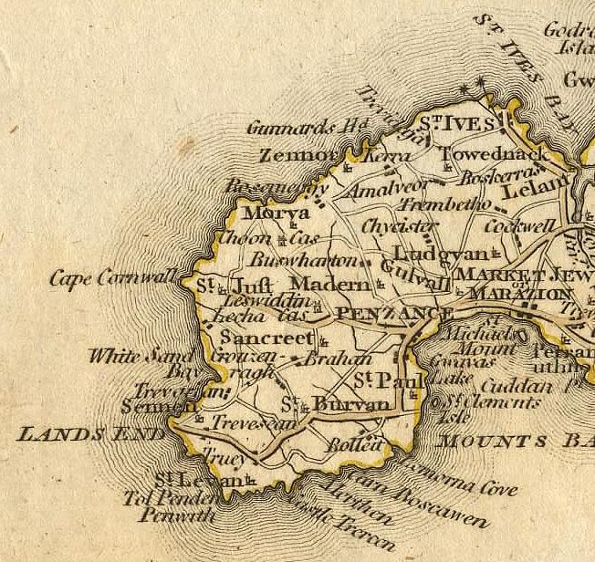
- Robert Morden, 1696. This map was published in the Gibson 1696 edition of Camden’s “Britannia” in English translation. It is superior in appearence to most earlier editions, being a lot less cluttered. I have an extract of West Penwith here (82K).
- Joel Gascoyne 1699. This is
a large scale (just under 1" to the mile) county map
completely re-surveyed and containing a gazetteer. It is of
historical and national significance being the first county
map at this large scale and also the first to show parish
boundaries. It was reproduced in facsimile in 1991 by the
D&CRS with a commentary by William Ravenhill and O. J.
Padel. ISBN 0 901853 34 8.
- George Bickham 1748. This is
an interesting example of what passed for a map in the
C18th. It was published in a book called
“The British monarchy or description of the dominions
of Great Britain”. G. Bickham, London: 1748. A
facsimile edition was published by Frank Graham, Newcastle
upon Tyne: 1967. The maps are birds-eye oblique views, that
of Cornwall being apparently from above the Tamar east of
Launceston, hence Penwith is rather distant and
distorted.
- Cary’s County Maps of 1787
have been republished in A4 and A3 sizes on quality paper by
MM Publications (Link Broken 17 Mar
2015) of Suffolk.
Here is a manageable extract of just West
Penwith (122K) from an online site that is no longer live.
- C. Smith 1801. I know very little about this map but
it seems to be a typical C18th map based on
earlier surveying but much better engraved. Alan Stanier has
a complete scan on his Cornwall (Link Broken 17 Mar
2015) page (370K) or for a more
manageable extract of just West
Penwith.
- The Ordnance Survey First
Edition 1" series was published from 1809–1813.
Sheet 33 was called “Penzance” and was
published in 1813. This was subsequently re-engraved in 1824
and 1839. Electrotypes were produced
from the 1850’s though to 1887. A facsimile is
available from David & Charles, Newton Abbot, Devon: 1970
& 1982. ISBN 0 7153 4403 X. This is reproduced from
the 1865 electrotype and is numbered sheet 95 in the David
& Charles series.
- John Cary 1811. Divided into hundreds. Finished size 20" square.
- C & G Cary 1820. 1/2" to one mile County up to Bodmin only. Other pieces were published separately to form a set for the whole of England and Wales by 1832.
- Thomas Moule 1836. This
again is a county map, part of a very decorative atlas for
the whole country. Those for England have been reproduced
with an 1842 text and modern colouring in a large format
book “The County maps of old England”
introduction by Roderick Barron, Studio Editions: 1990. ISBN
1 85170 403 5. A smaller volume is “Moule’s
county maps—The west of England” with an
introduction by Ashley Baynton-Williams. Bracken Books,
London: 1994. ISBN 1 85891 196 6.
- De La Beche, Sir. Henry. T. 1839. Geological Survey; Published on “Old Series” Sheet 33
- I. H. Rutger 1839 8"
to one mile Sennen parish. Each parish had a map for the
purposes of assessing and collecting tithes, often in
manuscript form and this was accompanied by a book which tied
the numbers on each field and building to the tenant for that
purpose (see Land Records). This
printed edition is thought to be reproduced from one of these
tithe maps for the benefit of land agents and other
interested people. £65 There is a
transcript of the corresponding book on this site and George Pritchard
has a transcript online with some photographs
and maps of each identifiable location. The Surveyor is
almost certainly John Harman Rutger, a surveyor listed in
Sarah Bendall's Dictionary of land surveyors
1530-1850. Rutger is listed as being active between
1827–57 particularly in Cornwall producing estate, rail
road and tithe maps. The publisher Dean & Co were also
known as Dean & Munday, they were based in Threadneedle
Street since 1811 and from 1847 traded from other premises.
[Thanks to Robert Laurie of the British Library for this
information.]
- Plan of the lands in the estates
of Hellesvean, Trowan and Ayr in the Parish of St. Ives, the
property of Edwin Ley Esq. 1841. 3 chains to one inch, a
typical minor estate map.
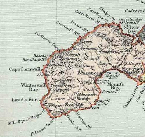
- The New Series Ordnance Survey 1" published from 1872.
Alan Godfrey Maps have a reproduction of
the 1888 edition available [No. 351
in his catalogue], which includes a large scale plan of St.
Just, an extract from 25" sheet LXXIII-2 (1906) described
below.
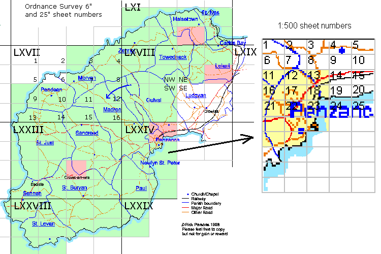
- The Ordnance Survey 6" series.
The first edition was 1880 and the second in 1906–9.
Each county was divided into 6 mile by 4 mile sheets
which were numbered (usually roman numerals) from West to
East and North to South as shown in this diagram. These were printed in
quarters marked NW, NE, SW & SE but were often
re-assembled on linen for sale in convenient groups as
demanded. I have one of these made up from LXI SW/SE (+NE
margin) and LXVIII NW/NE 6 miles by 4 which covers St. Ives,
Towednack, Zennor and Lelant. It is dated 1891 and has been
hand coloured to show the areas covered by some of the tin
mines. I also have separate quarter sheets of the second
edition dated 1908 LXVII NE (+ LXIA SE inset)
Morvah/Zennor, LXVII SE Sancreed/Madron, LXVIII SW
Madron/Gulval and LXXVIII NW Sennen/St. Levan (areas marked
in pale green on diagram). The first edition 6" maps
have been put online by Landmark in 1/16
sheets scanned at 300dpi. These come out at about 120K each
so navigation can be a bit slow due to the image size.
- Report of the Boundary Commissioners for England and
Wales—New Divisions of County; Eyre and Spottiswoode,
London: 1885. A very useful map as it shows the official
boundaries (proposed and presumably adopted) at that
time These are online for the whole country at London Ancestor. I have extracted West Penwith.
- The
Ordnance Survey 1:2500 (25") series was first published in
1880. The sheet numbering is the same as for the 6"
series above but each one is divided into 16 parts numbered
West to East, North to South as shown in this diagram. Often these become
available as composite or part maps made up for estate,
mining or corporation purposes. I have one which is part of
sheet LXXIII-11 (c1910 edition) which covers the tiny area
from modern grid ref. 391272 to 406286 (St. Buryan parish)
but in sufficient detail to show every building, numbered
fields and with the roads true to scale (area marked in pink
on diagram).
- The
Ordnance Survey 1:500 series is as big as you can get and
then, generally, only in towns. The sheet numbering is
the same as for the 25" series above but each one is further
divided into 25 parts numbered West to East, North to South
in the same fashion as the 6" as shown in this diagram. The reference to a
sheet looks like LXXIV 6.3 where the roman numbers are the 6"
sheet, the ordinal is the 25" sheet and the sub-ordinal is
the 1:500 sheet. I have only ever seen these in libraries but
was fortunate to be given a set of copies at reduced (1/3)
scale for the town of Penzance. I think that these are dated
1877 and are sheets LXXIV 2.11, 12, 13, 16, 17, 18, 21, 22,
23 and 6.1, 2, 3, 6 & 7 (area marked in yellow on
diagram)..
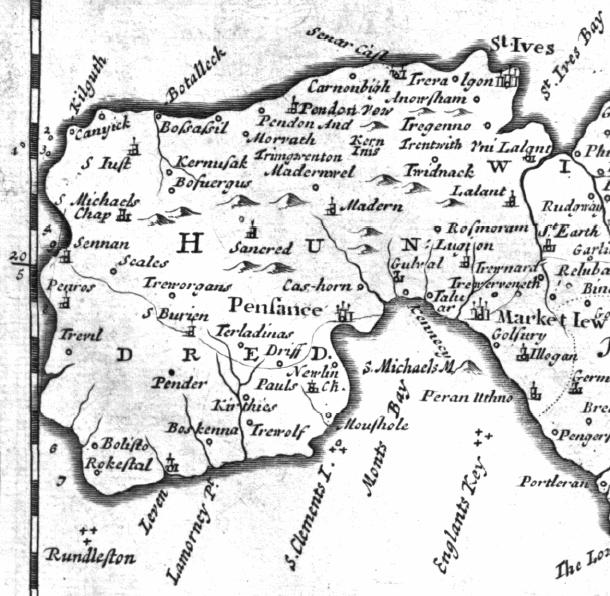
- Mackenzie 1895. I know nothing about this map but it
seems to be a typical C19th map. Alan Stanier has
a complete scan on his Cornwall (Link Broken 17 Mar
2015) page (624K) or for a more
manageable extract of just West Penwith.
- Dixon, E. E. L., MacAlister, D. A., Reid, C. & Wilkinson, B. S. N. 1907. Geological Survey at the six inch scale. Originaly drawn 1898–1903.
- The 1" Ordnance Survey Third
Edition (New Large Sheet Series). This is the first
colour series, published from 1905 to 1918, and is useful as
it shows (civil) parish boundaries. Most of West Penwith is
on sheet 151, “Land’s End” (my edition is
dated 1911—print code 5.11 dissected onto linen and was
distributed by Alfred Wilson, bookseller, London).
- The Ordnance Survey 1/2" series
Sheet 35 “S. W. Cornwall & Scilly Isles”.
My copy, mounted on linen, is dated 1913—print code
3536.R.35-6.
- The 1" Ordnance Survey (Fourth)
Popular Edition. This edition included a grid system
which was valid over individual maps of the same edition.
Each was divided into squares 2 miles to a side from an
origin in the top left corner—numbered along the top
and lettered down the sides. It was published from about 1919
to 1926—sheet number 146 shows “Land’s End
& Lizard”. My copy is dated 1926—print code
3000/26 with a standard red cover.
- The 1" Ordnance Survey Fifth
Edition. Published from 1934 in a standard and a relief
edition. This edition included a precursor to the National
Grid—the country was divided into squares 5000 yards to
a side from an origin to the south and west of England. This
required a reference of two seven or eight digit numbers to
locate a point to within 100 yards if the last two digits of
each were zero. Sheet number 146 shows “Land’s
End & Lizard”. My (standard) copy has print code
5035 (presumably 1935) with a standard blue cover.
- The National Series 1" Ordnance
Survey also called the New Popular or Sixth Edition. The
first to include the standardised National Grid reference
system of one Km squares and area code letters. This required
only two letters and a single six digit number to locate a
point to within 100m, sufficient accuracy for most purposes.
It was published from 1940 to 1947 and they had also learned
how to fold a map for ready reference on the move. Sheet 189
was “Land’s End” which is all in the
“SW” grid area. My copy is dated 1946—print
code 40,046 with a standard red & buff cover. See
also Kain & Oliver 2001 below.
- Harbour map/chart of St. Ives
and Hayle issued by the Hydrographic department of the
Admiralty. corrected to 1943 and presumably restricted
material for wartime.
- The Seventh Series 1" Ordnance
Survey. This was published from 1952 to 1972. Sheet 189
was “Land’s End”. My copy is dated
1961—print code A with a standard red & buff
cover. I also have an uncommon Central Electricity
Generating Board edition of this one with the pylon routes
marked in greater detail.
- The Ordnance Survey 2 1/2" series. The sheet numbers required are SW32, 33, 42, 43 and 53.
- The Ordnance Survey 1:25,000
Pathfinder series. West Penwith requires two
sheets—1368 “Land’s End” (was SW
32/42, my edition is dated 1972) and 1364 “St. Ives
& Penzance (North)” (was SW 33/43, my edition is
dated 1989).
- The Ordnance Survey 1:100,000
Petty Sessions and Administrative areas map. One sheet
for the whole of Cornwall showing clearly showing civil
parish boundaries.
- Goode, A. J. J., Taylor, R. T. & Wilson, A. C. 1970–76. Geological Survey at the six inch scale resurveyed.
- The current (from 1974) Ordnance
Survey 1:50,000 Landranger series. West Penwith is on
sheet 203, “The Lizard & Isles of Scilly” (my
edition is dated 1989). There is a set of
Industrial Archaeology
MapNotes for this sheet by I.A.Recordings which guides you to the key sites of the area,
especially the mines and related industries. The majority are
around Camborne/Redruth but there are a few listed in the
West.
- Brown, G. M. 1984 British
Geological Survey sheet 351/358 Penzance; Drawn on the
western part of the 1:50,000 sheet 203, 1974 excluding the
Isles of Scilly. It was (is?) also available in 20 x 1:10,000
sheets to special order.
- The current (from 1996) Ordnance
Survey 1:25,000 Explorer series. West Penwith is on sheet
102 “Land’s End, Penzance and St. Ives”
(previously sheet 7).
- Estate publications Red
Book—Cornwall; Tenterden, Kent:various. ISBN
0-86084-315-7. This modern publication is very useful for
locating streets in the larger towns.
- Kain, Roger J. P. & Oliver,
Richard R. Historic parishes of England & Wales;
University of Essex, Colchester: 2001. ISBN 0-9540032-0-9
This is an excellent book that acompanies a set of CDROMs
(ISBN:0-9540032-1-7) which overlays the 6th series OS map
with accurate parish boundaries and also provides a gazetteer
of parishes.
-
I also have numerous lesser editions
for reference including
- Geographia 5 miles to 1" road map No. 2 “South West Counties” (undated but probably c1965)
- Geographia 3 miles = 1" road map “Cornwall” (undated but probably c1950)
- Ordnance Survey 1:250,000 Sheet 15 (1974)
- Bartholomew’s 1/2" Contoured Sheet 1 “Cornwall” (1956 & 1959)
- Similar maps to these showing just Penwith and larger
scale of Zennor and Towednack are on Nick
Berryman’s Cornwall Index pages. (40–100K
each) (Link Broken 9 Apr 2007)
I can recommend ![]() Lesley Aitchison who has a good selection of
maps of Cornwall available for sale by post via a monthly
catalogue.
Lesley Aitchison who has a good selection of
maps of Cornwall available for sale by post via a monthly
catalogue.
![]() David Archer Maps has a good range of old
Ordnance Survey maps available.
David Archer Maps has a good range of old
Ordnance Survey maps available.
See 
![]() MapPlanet.com for an
interesting way to navigate the world.
MapPlanet.com for an
interesting way to navigate the world.
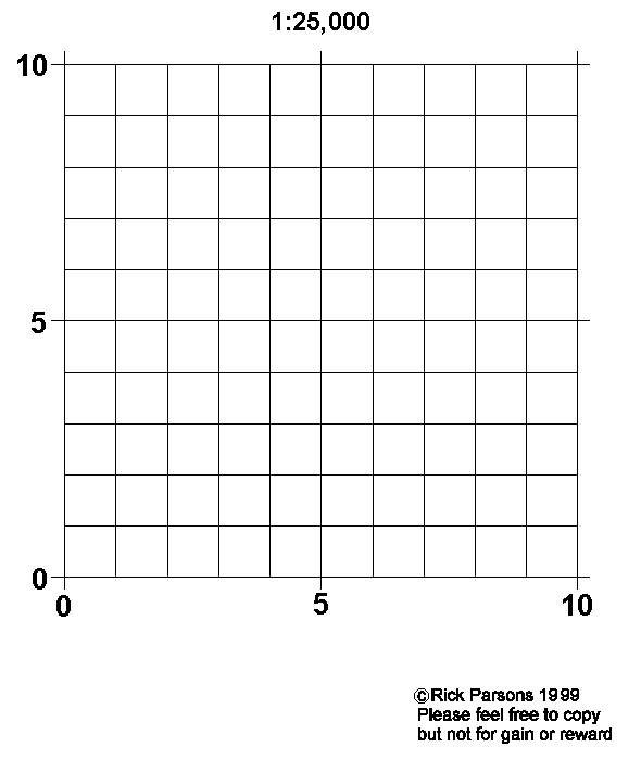
Gadget
As an aid to reading 1:25,000 Ordnance Survey maps I offer you this little invention. It consists of a 4cm x 4cm square divided into a 4mm grid printed onto clear plastic. It comes in the form of a downloadable GIF file. Save this as a file and print it onto an acetate intended for overhead projectors then cut it out and you are away. If you can’t print to acetate, then print to paper and get a copy shop to transfer it to acetate for you. the only requirement is that your printer must operate at 300DPI and be reasonably accurate in registration.
BEWARE—DON’T print it from your browser print button, it will come out much too large, save it to a file and use Paint Shop Pro or another gif editor.
 Webmaster
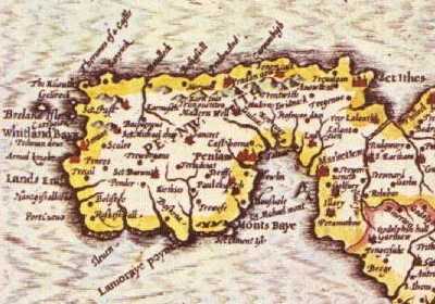