
ZENNOR CROMLECH.
Prehistoric, British and Roman Periods.
No part of Great Britain can trace further back into the past than can West Cornwall. South Wales can indeed point to more remains of classic antiquity, and boast more of a more ancient Christian hierarchy; but to Cornwall belongs the prestige of having been the first depot of intercourse with the Eastern world, and the earliest centre of civilization in this island.
In a paper read before a society of savants in 1886 on the then recent discovery of shells in the Saint Erth clay-beds, Professor R. W. Bell remarked that the deposit of clay in the Saint Erth sandpit was one of the most interesting discoveries which had been made in Tertiary geology for some years. His remarks tend to show that the Saint Erth Valley was within historical times an arm of the sea, or, as he terms it, ‘a somewhat shallow gulf occupying at least the valley in which Saint Erth is placed, and which probably connected the northern and southern seas of Cornwall until a comparatively recent period.’ This paper was supplementary to one previously read before the Geological Society of London. The present line of the railway between Saint Ives and Penzance runs almost parallel with this valley, and from the carriage window the traveler will see from its general appearance that this was once under water, it being for nearly its whole length a morass. Within comparatively recent times, strong gales have threatened to flood the Saint Erth Valley, and restore the original appearance of the island from which the Phœnicians obtained their tin.
An ancient tradition asserts that the tin used in the construction of Solomon’s temple was obtained from the Godolphin Hills. At all events, the Land’s End district was certainly the depot which furnished the East with its tin in ancient times. The Saint Ives district is not without architectural remains which may fairly be ascribed to this early period. As in the West of Ireland, and elsewhere in Cornwall, these are generally cyclopean, so called from the massiveness of the stones which compose them.
A relic of this description is still to be seen on the Island at Saint Ives, and is popularly termed the Two Edges. It consists principally of two walls about seven feet high meeting at a right angle, the space between being level with the top of the walls. It is evident that the Island has always been a fortified place; for during the Middle Ages it was defended with dry-stone walls, traces of which still remain, and is now protected by a small fort for two guns in charge of a corporal of the Royal Artillery. In the absence of violent innovations, the massive rampart of the Ancient Briton will probably survive the military redoubt of the nineteenth-century engineer. The labour involved in the construction of the Two Edges must have been stupendous, though apparently the materials were obtained in the Island itself. No record is left of the local chieftain to whom the erection of the Two Edges is due, nor of any battles fought upon the island; but a stone axe or celt was found in 1887 at Saint Ives, which may have been wielded by one of the garrison or besiegers of this prehistoric stronghold. Some Cornish antiquaries are strongly of the opinion that such dry-stone forts as this on the Island, which they name Cliff Castles, were erected to be the last refuges of the Stone Men (the ‘Giants’ of folklore), whom the first Celtic invasion drove to the sea board.
Traces of another fort, consisting of a vallum of earth and stones running across an isthmus, exist on the promontory called the Gurnard’s Head, in the parish of Zennor. The Cornish name of this headland is Treryn Dinas, which signifies a fortified place. The late Davies Gilbert, by the way, purchased this promontory from a desire to possess what is considered one of the most interesting geological formations in the country.
The westernmost headland in the parish of Zennor, near the mouth of the stream which separates Zennor and Morvah, and not far from the villages of Bosigran and Rosemergy, is known as Bosigran Castle. It is fortified on its isthmus by a thick dry-stone vallum. In the centre of the promontory is a large block of granite marked with basins, which is called the Castle Rock; and near this is a large stone scooped, as it were, through the top, known as the Giant’s Cradle. A few yards nearer the sea is a logan-rock over nine yards in circumference, with basins on the top. Norden mentions a fortification called Castle Anowthan, which he describes as ‘a craggy rock on the top of a hill near Zennor, some time trenched about and built with stone, as appeareth by the ruins of the walls.’
The most perfect example of a hill-fort in the Saint Ives district is that on the summit of Trencrom. The top of this hill is nearly flat, and around it are the remains of a very extensive circular vallum of earth and stones, upwards of twenty feet in thickness. The entrance on the south-eastern side of the enclosure is about twenty feet wide, and has large upright blocks of granite at the inner corners. Opposite on the other side is a similar gateway. The vallum does not form a perfect circle, but is turned out of its regular course in order to unite it with two carns, between which was another entrance nearly opposite Trink Hill. On the largest of these carns are rock basins, known as the Giant’s Chair, the Giant’s Cradle and the Giant’s Spoon. A serpentine road passes up the hill, through the gateway, and on to the centre of the enclosure. To the right of this road, inside the circle, are traces of a large circular barrow of earth and stones, and nearer the top of the hill are the remains of several circular enclosures, about twenty-five feet in diameter, which seem to be the foundations of similar barrows. Outside the vallum is the Giant’s Well, and on the south side of the hill is the Twelve o’Clock Stone, on which the sun rays fall in such a manner that the country people can tell the hour by the direction of the shadows. (Abridged from Halliwell’s ‘Rambles in Western Cornwall,’ p.74) Here also was formerly an ancient granite cross; it was removed about twenty years ago by some person unknown.
Mr. Halliwell mentions a stone on the Church-town Hill, Zennor, called the Giant’s Chair, and on the same hill a recess in the rocks known as Giant’s Bed. The reader will observe the frequent use of the term ‘giant’ in connection with rude-stone monuments and natural carns. As we shall have more to say about the giants in a later chapter, we will now only remark that they must be taken to represent the popular conception of the Stone Men, who in these rocky fastnesses held their own for some time against the Celtic Aryans. According to an old local chronicle, to which we shall have frequent occasion to refer, a barrow or tumulus known as the Giant’s Grave, near the town of Saint Ives, was opened about the year 1690, and in it was found ‘a tooth an inch broad.’ No doubt some pre-Aryan chieftain was interred there with his horse.
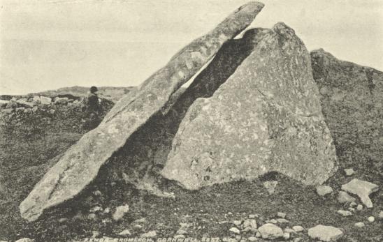
Several cromlechs are to be found in the neighbourhood of Saint Ives, and of these nearly all are in Zennor parish, the most noteworthy being the celebrated Zennor Quoit or Cromlech. The following paragraph appeared in the Cornish Telegraph of September 4, 1861:
‘Zennor Quoit, one of our local antiquities, has recently had a narrow escape. It consists of seven stones, one of which is a large granite slab which lies in a slanting position against the tallest of the uprights. A farmer had removed part of one of the upright pillars, and drilled a hole into the slanting quoit in order to err ect a cattle-shed, when news of the vandalism reached the ears of the Rev. W. Borlase, vicar of Zennor, and for five shillings the work of destruction was stayed, the vicar having thus strengthened the legend that the quoit cannot be removed. From Zennor Quoit you can see that of Mulfra, and from Mulfra you can behold the Chûn and Zennor Quoits. The Zennor Quoit or Cromlech is not so often visited as some of the other cromlechs, but it is a remarkable group of stones. There are no other blocks of granite near. It lies directly between Zennor and Towednack churches, about three quarters of a mile from each. The view from the quoit is very extensive. It commands a beautiful prospect of the British Channel, and eastward the county as far as Redruth, with the Bodmin range in the distance.’
In Dr. Borlase’s time this cromlech, which is of thin moorstone, was surrounded by a stone barrow; but a mere apronful of the stones now remains. Originally, no doubt, the kistvaen, i.e.massive blocks of the cromlech, merely formed an inner chamber, the whole being a mound of earth and stones. Dr. Borlase (‘History of Cornwall,’ London, 1769) describes the cromlech as it appeared in his day as being ‘quite inclosed and buried, as it were, in the barrow.’ His book has an engraving of this cromlech, showing the top-stone in its place, and stones heaped round the base of the structure. He says:
‘The kistvaen of the Zennor cromlech is so close that it is with great difficulty any man can get into it’ (p.227).
At p.231 we read the following further particulars as to this monument:
‘On the top of a high hill, about half a mile to the east of Senar Church-town, stands a very large handsome cromlêh; the area inclosed by the supporters is … six feet eight inches by four feet, and points … east and west (Plate XXI., Fig. III. and IV.). The kistvaen (Fig. IV., No. 5) is neatly formed and fenced every way, and the supporter … is eight feet ten inches high, from the surface of the earth in the kistvaen, to the under face of the quoit … The great depth of this kistvaen, which is about eight feet … is remarkable … the stone barrow, fourteen yards diameter, was heaped around it, and almost reached the edge of the quoit, but care taken that no stone should get in to the repository. This quoit was brought from a karn about a furlong off, which stands a little higher than the spot on which this cromlêh is erected; and near this karn is another cromlêh, not so large as that here described, in other respects not materially different.’
When, in the summer of 1882, the Penzance Natural History and Antiquarian Society paid a visit to Zennor, Mr. Borlase, one of the members, met with a man who had made a find beneath the Zennor Quoit. The man explained that about a year ago, finding that other people were searching about, he and his son thought they would have ‘a bit of a speer too.’ After removing some of the earth, they came upon a flat stone, which they ‘shut’ (blasted). They then removed more earth and came upon another flat stone, which they also ‘shut.’. Underneath it they found what Mr. Borlase said was an ancient whetstone, which no doubt was buried with the dead, in order that he might have something to sharpen his weapons with in ‘the happy hunting grounds’ to which he was supposed to have gone. Mr. Borlase had found similar stones, with urns containing the ashes of the dead, in different barrows. Under this quoit he found part of an urn. Mr. Borlase expressed a hope that there would be no more ‘shutting’ near the quoit, because it ought to be regarded as sacred as the grave of a father—as it was, indeed, the grave of one of our forefathers. Mr. Westlake mentioned that there were remains of an old British village on Zennor Carn, a short distance off.
A few hundred yards to the back of the church at Zennor is a very good specimen of a logan-rock, which visitors may examine without the fatigue of hill-climbing, for (unlike most rocking-stones) it is on a comparatively level plain. No matter how many persons may be sitting on the top, proper pressure in the right direction will set it rocking like a cradle. This is termed by the peasantry the Giant’s Rock. It is nineteen feet long, three feet thick, and has on top several smooth cavities termed by Borlase rock-basins. It has lately been the fashion to laugh at the Doctor’s ‘rock-basins,’ on the ground that his head was too full of Druids to permit of his seeing that these hollows, instead of having been artificially scooped out, are in reality the result of the action of the weather. But here it seems to me that people err in the opposite direction. After a very careful examination of rocks, principally at Carn Brê, near Redruth, I am convinced that the round, shallow, rough depressions caused by the friction of fragments of the granite, blown around and around on the surface of the boulders in storms of wind and rain, are quite distinct from the deep, smooth, intricate cavities assumed by Borlase to be the handiwork of Druids. The real rock-basins are as certainly artificial as the Cornish crosses of a later age. There is no doubt that the cromlech was, down to the period of the Roman occupation, the customary style of tomb for prominent chieftains among the Celts; as to the logan-rocks, it appears certain that they are due simply to the gradual wearing away of the soil, leaving the granite thus poised in some few instances.
The moorlands in this neighbourhood can show a great number of rude-stone monuments in various stages of dilapidation, and many more have within the last century been broken up for road-making. There are logan-rocks on Rosewall Hill and Carn Stabba. Between Saint Ives and Zennor, on the lower road over Tregarthen Downs, stood a logan-rock. An old man told Mr. Hunt’s informant that he had often logged it, and that it would make a noise which could be heard for miles.
At Balnoon, between Nancledra and Knill’s Steeple, some miners came upon two slabs of granite cemented together, which covered a walled grave three feet square. In it they found an earthenware vessel containing some black earth and a leaden spoon. The spoon was given to Mr. Praed of Trevetho. (Hunt’s ‘Popular Romances.’)
There is a small discounted cromlech in Zennor parish, four miles and a half north-west by north of Penzance, nearly two furlongs from Bosphrennis, and near the west side of the path leading from Bosphrennis to Bosigran. Around it is a heap of earth and stones, the remains, doubtless, of a barrow which once covered it.
Between this small cromlech and the large one next to be described was another of considerable size in the estate of Trewy, but not a vestige of it now remains. It stood about a furlong south-east of Gundry Cave. The other is a remarkable barrow, 110 feet in circumference, raised on a small natural cairn, on an eminence nearly five furlongs south-east by north of Zennor Church and about two furlongs from the east side of the road to Penzance. This barrow is depressed at the centre in the form of a bowl. At the bottom of the hollow was a horizontal slab six or eight feet square, supported by others set upright, all which have since been removed. This singular barrow must therefore have been originally merely a heap covering a cromlech, and the depression in the centre a modern excavation made to ascertain the contents of the barrow. (‘Archæologia Cambrensis,’ Series III., vol iii., 1857.)
Dr. Borlase says:
‘In the parish of Senor, I met with a remarkable cirque (Plate XV., Fig. IV.), formed by small stones thrown loosely together in a circular ridge. At the entrance A, there is one tall pillar. The dimensions of it may be found by the scale annexed. I judge this to have been an elective circle; but why this round should consist of such a number of small stones heaped together, and the rest of a few, and so much larger, I cannot guess.’
Halliwell was informed that this circle was situated at the village of Rosemergy. It has long disappeared.
Courtney (‘Guide to Penzance,’ 1845) says:
‘Another small cromlech (unnoticed by Borlase or any other writer) has lately been discovered in a croft near the village of Bosprennis in this parish [Zennor]: it is about five feet in diameter and nearly circular; it is dismounted, and lies on its flat: three of the upright stones on which it rested still remain: the fourth is either under the cromlech or has been taken away. This piece of antiquity is nearly hidden by the furze bushes, but it was no doubt formerly well known, as the croft in which it stands is still called Quoit Croft.’
At a visit paid to Zennor by the Penzance Natural History and Antiquarian Society, in September, 1883, a halt was made at Pennance to visit an ancient barrow known locally as the Giant’s House, which to the disgust of lovers of the picturesque, had in view of the visit of the society been ‘shaven and shorn’ of its covering of bramble and bracken. Arriving at Treren, the president led the way down the path to Gurnard’s Head, as far as an enclosure with walls in one place twenty feet thick and having an extended entrance, and was now used as a sheepfold. It had been in its present state for at least a hundred years. Could anyone tell him what it was? Mr. Cornish proceeded to speak of the Pennance barrow, referring to the peculiar walling of the interior, and the manner in which the slabs were laid on the roof. When he first knew it twenty-one or twenty-two years ago it was used as a calves’ house, and they might have detected a faint odour of that use to-day. The barrow was one of many in the district. On the eastern slope of the hill above Trereen were three of precisely the same construction. One was used as a pig’s house, and another for storing fern for fuel. A great many barrows had been destroyed in the course of improving land a few years ago. Their use was no doubt sepulchral. When he discovered one of the barrows on the hills above, a man told him that he had found an urn in it, and he produced it from a hedge. It was now in the museum of the society. There was a curious superstition that if an urn found in a barrow were taken home, the owner would be sure to come for it; and that the only way of avoiding that was to break the urn and bury it in a hedge.
On Cuckoo Hill, eastward of the village of Nancledra, there stood about forty years ago two piles of rock some eight feet apart, united by a large flat stone carefully placed upon them, thus forming a doorway which was, as Mr. Hunt’s informant told him, large and high enough to drive a horse and cart through. It was formerly the custom to march in procession through this ‘doorway’ in going to the Twelve o’Clock Stone, on which children were placed to be cured of rickets. (‘Popular Romances of the West of England.’)
At a point where the four parishes of Zennor, Morvah, Gulval and Madron meet, is a flat stone with a cross cut on it. Seven Saxon Kings are said to have dined on this. The same is related of a similar stone near the Land’s End.
 Webmaster